Learning online has become an essential part of education globally. Kartoza has answered the call for up-to-date, engaging and dynamic teaching material by updating our QGIS and GeoNode teaching platforms. Kartoza uses our open source 'changelog' platform, that allows for continual updates and customisation of material to deliver cutting-edge training.
The Kartoza Changelog is a web platform that aims to be a simple, all-encompassing educational tool. Software projects and their training courses can be managed and showcased and lessons in each course appear in sequential sections containing worksheets. Each worksheet includes instructions and sample data to download and experiment with. The worksheets can also contain links to external resources.
"I am delighted with the Changelog as a training tool; it's effortless to manage, update, use and navigate through! It has made it easier for the interns to participate in content creation and to prepare for the lessons in which we act as tutors." - Zinzi Xakayi.
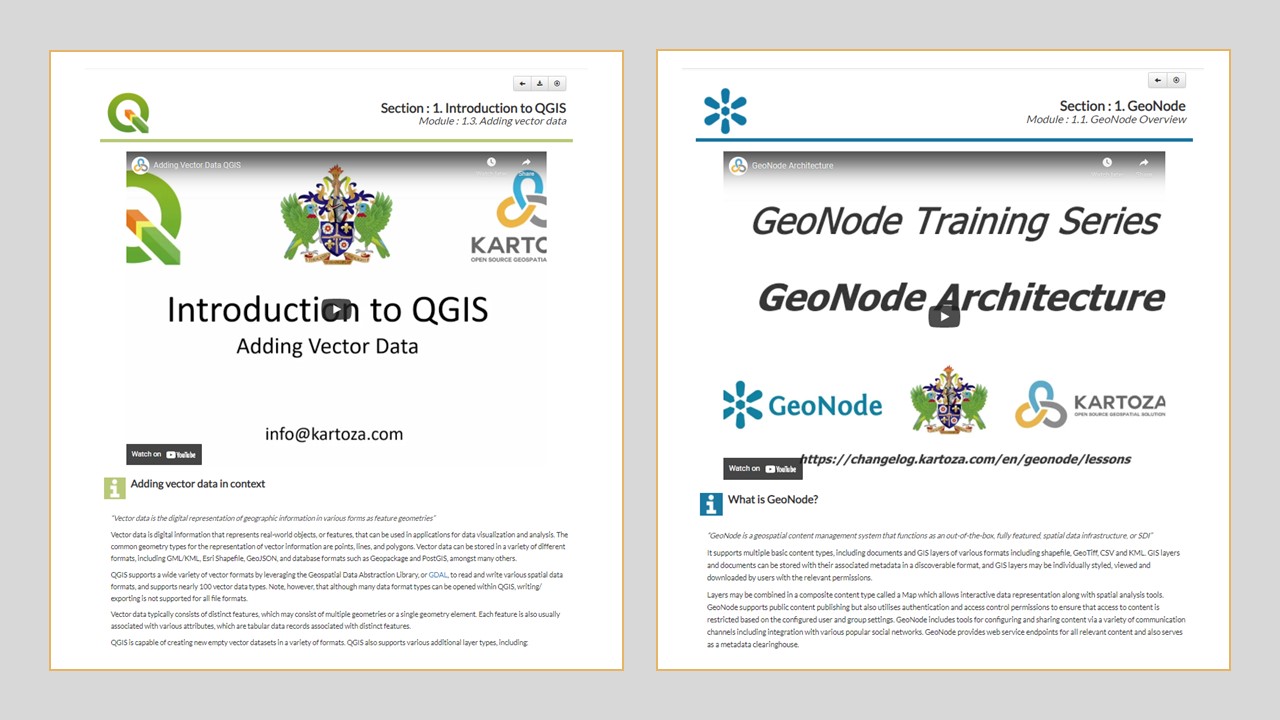
After reviewing the worksheets and receiving student reviews, it was evident that some beginners may initially find the Kartoza worksheets challenging. We decided that basic instructional videos should be made to assist such candidates. We created the new material to encourage independent self-study and exploration of the software, and to encourage students to attend and engage in the online classes. The Kartoza intern group was challenged to go through the lessons and create the explanatory videos to accompany each exercise (Fig.1).

Figure 1: QGIS and GeoNode worksheets with instructional videos embedded in the worksheet.
The QGIS courses are extensive and include everything from exploring the interface and loading layers through manipulating symbology and map creation, to geoprocessing and statistical analysis. We made about sixty QGIS videos. Similarly, we made thirty short instructional videos for the GeoNode worksheets.
Everyone learns differently--including multimedia assists in conveying the message to a wider audience. The QGIS videos are spoken step-by-step tutorials with short explanations. The GeoNode videos are text-based instructional videos. Both allow the student quickly and easily to follow the steps of the exercise and check their knowledge. The videos are at the top of the worksheet for ease of use and access and are often a good introduction to the content. Above and beyond adding videos, we added a button that allows for downloading the exercise data in the worksheet. We added more information to several worksheets and we made the steps easier to follow, without spoon-feeding the answer.
An editor can add worksheets with a click of a button. When creating the worksheets, defaults and templates ensure consistent structure and format for all the worksheets. Visually, the lessons are simple and standardised. A few further improvements are in the works. A more colourful page with a separate navigation bar at the top would improve usability. Allowing the addition of new worksheet sections and the use of different fonts would allow for a more dynamic developer experience.
"All in all, the Changelog website gets the job done in displaying the worksheet information in a simple yet effective way with the additional use of visual aids such as tables, videos, and external websites for additional information. The Changelog allows for the creation of worksheets in a standard layout and constant updating. The website is an out-of-the-box project management platform, which it delivers on extremely well. Still, a few features and changes could be added to make the experience and platform more flexible and visually appealing."- Nicholas Sun Hing.
In testing the student's knowledge, there is a limit to the quizzes available in the Changelog. The student can not quickly see what questions they got correct or incorrect, which would be improved upon by accepting feedback from the quiz. Currently, this issue is addressed on the course training platform Moodle. Moodle is a FOSS education system on which a course outline, links to the material, the lessons, recorded training sessions, assignments, and quizzes. The Moodle system is easily editable, and students are added with login credentials allowing the tracking of learners' progress by the course coordinators.
The Intern team is eager to continue work on the changelog platforms and create new content for FOSS software. Good online education and courses take time and planning to create but are the future of education. Online education is the most effective way to quickly and impactfully learn geospatial skills. With the new, improved and flexible changelog sites, Kartoza is leading its students on a journey of discovery culminating in the mastery of QGIS and GeoNode.
Contributing Authors: Nicholas Sun Hing, Zinzi Xakayi and Amy Burness
For more on FOSSGIS training with Kartoza see Kartoza Training & Education.
For some interesting videos on using QGIS, visit the Kartoza Road to Nerdvana series on YouTube.
Also see the QGIS Training Manual and A Gentle Introduction to GIS
Share on Twitter Share on Facebook Kartoza
Comments
There are currently no comments
New Comment