A new QGIS plugin that allows browsing STAC API catalogs inside QGIS has been released. The plugin, developed by Kartoza and sponsored by Microsoft, is available for download and installation in the QGIS official plugin repository. Before this plugin was developed, there was an existing plugin that aimed at providing the same services, though it wasn't updated to use the latest stable release of the STAC API and was not being actively maintained.
The new plugin comes with features that give the user a comfortable interface and interaction in browsing STAC items in the searched catalog.
The plugin supports searching for STAC item resources, loading and downloading STAC items and retrieving information about STAC API services.
How to install the plugin
The plugin is available to download and install in QGIS from the official QGIS plugin repository.
To install the plugin, follow these steps.
- Launch QGIS and open plugin manager.
- Search for STAC API Browser in the All page of the manager.
- Click on the STAC API Browser result item and plugin information will show up.
- Click the Install Plugin button at the bottom of the dialog to install the plugin.
Available features
The plugin features can be categorised in two parts: Searching STAC resources and accessing STAC assets.
Searching STAC Items
The STAC API specification allows search for core catalog API capabilities and search for STAC item objects. The plugin supports item search and provides filters that can be used along with the search.
The corresponding STAC API service used when searching needs to ensure that it has implemented the /search API endpoint according to the specification.
The plugin contains the following filters that can be used when searching for STAC item objects.
- Date filter - users can search for single instance temporal resources or resources with a temporal range.
- Spatial extent filter - users can provide a bounding box against which the results should be filtered.
- Advanced filter - this enables usage of STAC API filter languages to provide advanced queries for the search. For more information see https://github.com/radiantearth/stac-api-spec/tree/master/fragments/filter.
Accessing STAC assets
Each STAC Item object contains a number of assets and a footprint. A GeoJSON geometry defines the full footprint of the assets represented by an item.
The plugin search results items contain a dedicated dialog for viewing, loading and downloading item assets into QGIS.
How to use plugin features
After installing the plugin in QGIS, the following section provides a guide on how to use the plugin.
Launching the STAC API Browser plugin
Three plugin menus can be used to launch the plugin in QGIS.
QGIS toolbar
In QGIS toolbar, there will be a plugin entry with the STAC API Browser icon. Click on the icon to open the plugin main dialog.
![]()
QGIS Toolbar
QGIS Plugins Menu
In the QGIS main plugins menu, Go to STAC API Browser Plugin > Open STAC API Browser
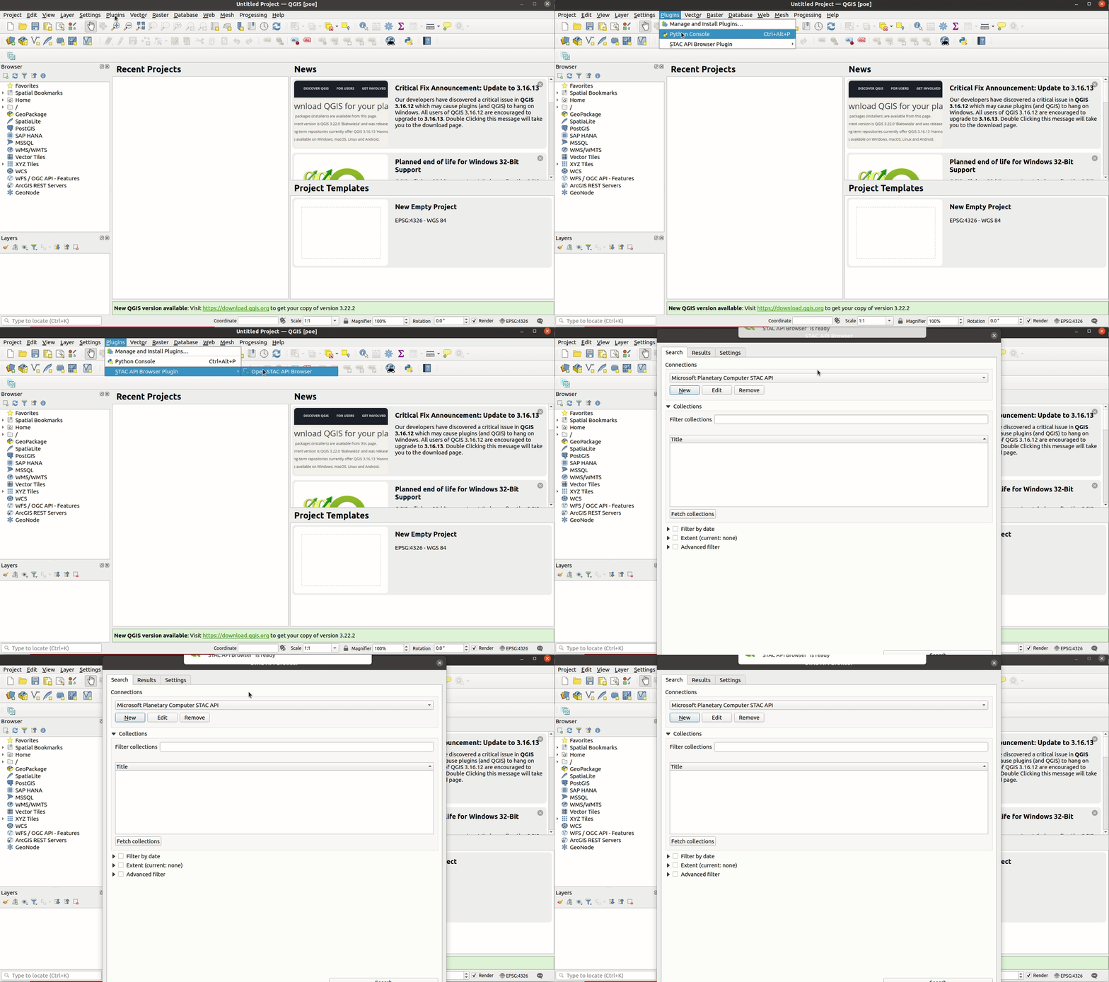
Screenshot showing how to use the plugins menu to open the plugin
QGIS Web menu
In the QGIS web menu, go to STAC API Browser Plugin > Open STAC API Browser
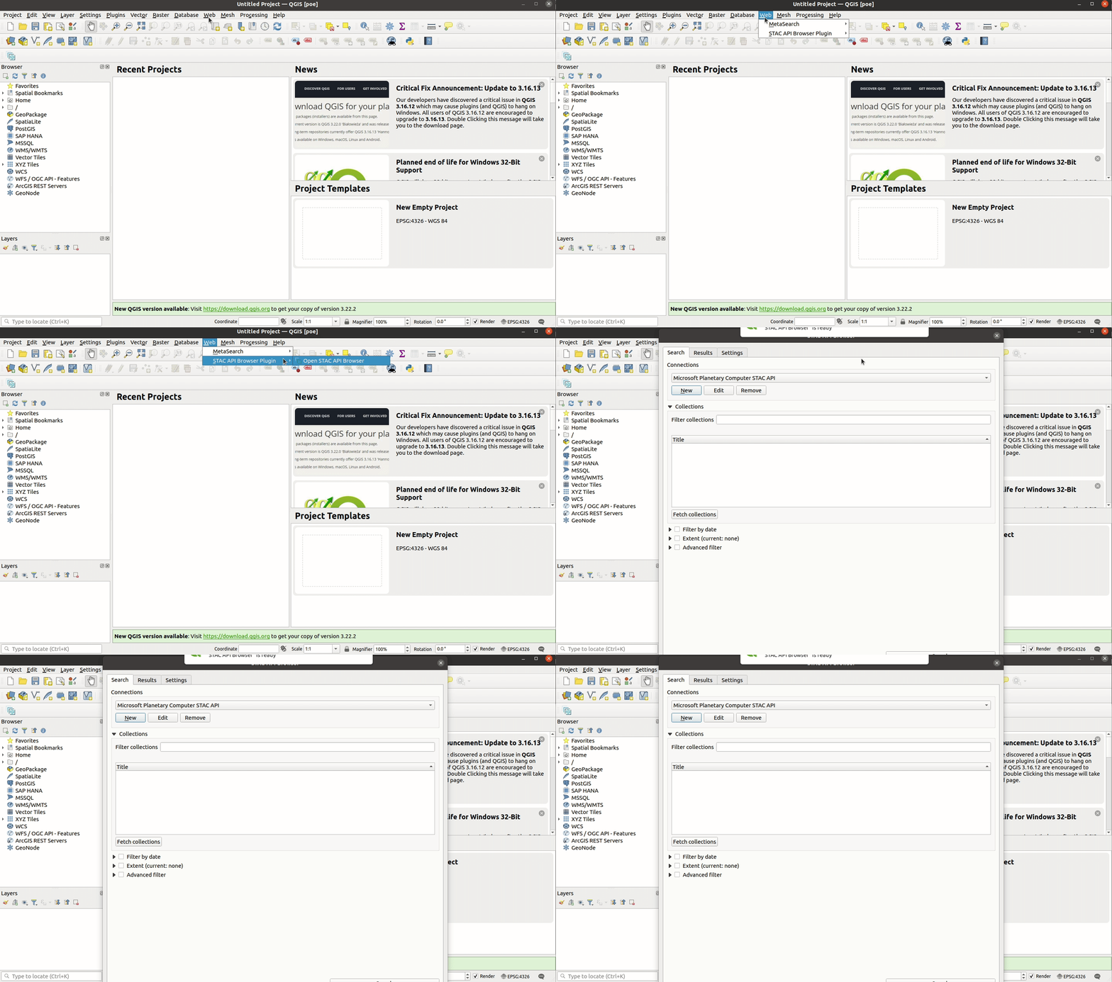
Screenshot showing how to use QGIS web menu to open the plugin
Adding a STAC API connection
The STAC API Browser provides some predefined STAC API service connections when installed for the first time.
To add a new STAC API service connection, click the New connection button, add the required details and click OK to save the connection.
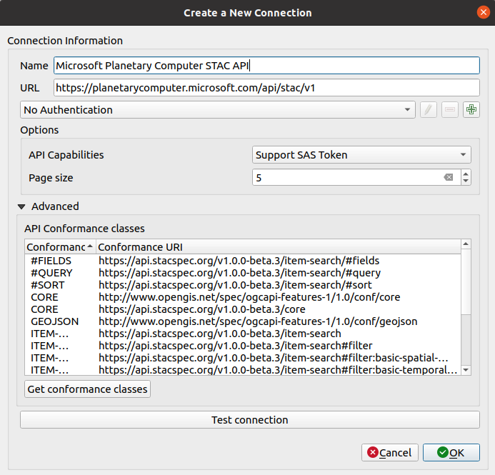
Connection dialog with Microsoft Planetary Computer STAC API details
The connection dialog contains an API Capabilities field which can be used to set the connection to use a SAS Token. The signing mechanism includes a token that has an expiry period. Users should look at the API documentation to find out about the expiry period of the token.
The Advanced group contains a list of the conformance types that the STAC API adheres to. When creating new connections, the list is empty. Users can click the Get conformance classes button to fetch the conformance
classes. The above image shows the https://planetarycomputer.microsoft.com/api/stac/v1 with a list of conformances classes that have already been fetched.
STAC API Items search
Using the search filters
All the search filters can be used only when their corresponding group boxes have been checked.
For the Advanced filter group, the available filter languages are based on the supported STAC API filter languages. When STAC_QUERY is used then filter input will be treated as a query text as defined in https://github.com/radiantearth/stac-api-spec/tree/master/fragments/query. If CQL_JSON is selected then you can use a CQL filter text as defined in https://github.com/radiantearth/stac-api-spec/tree/master/fragments/filter.
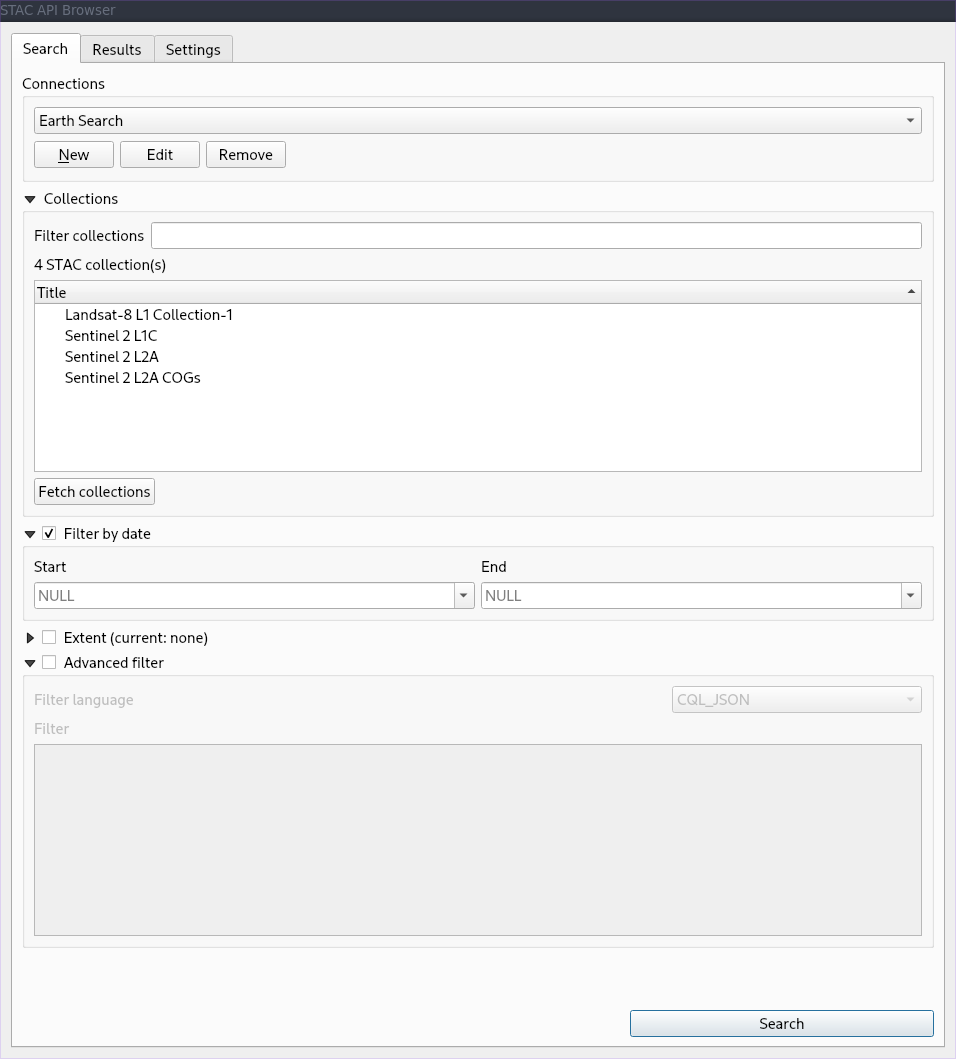
Available filters
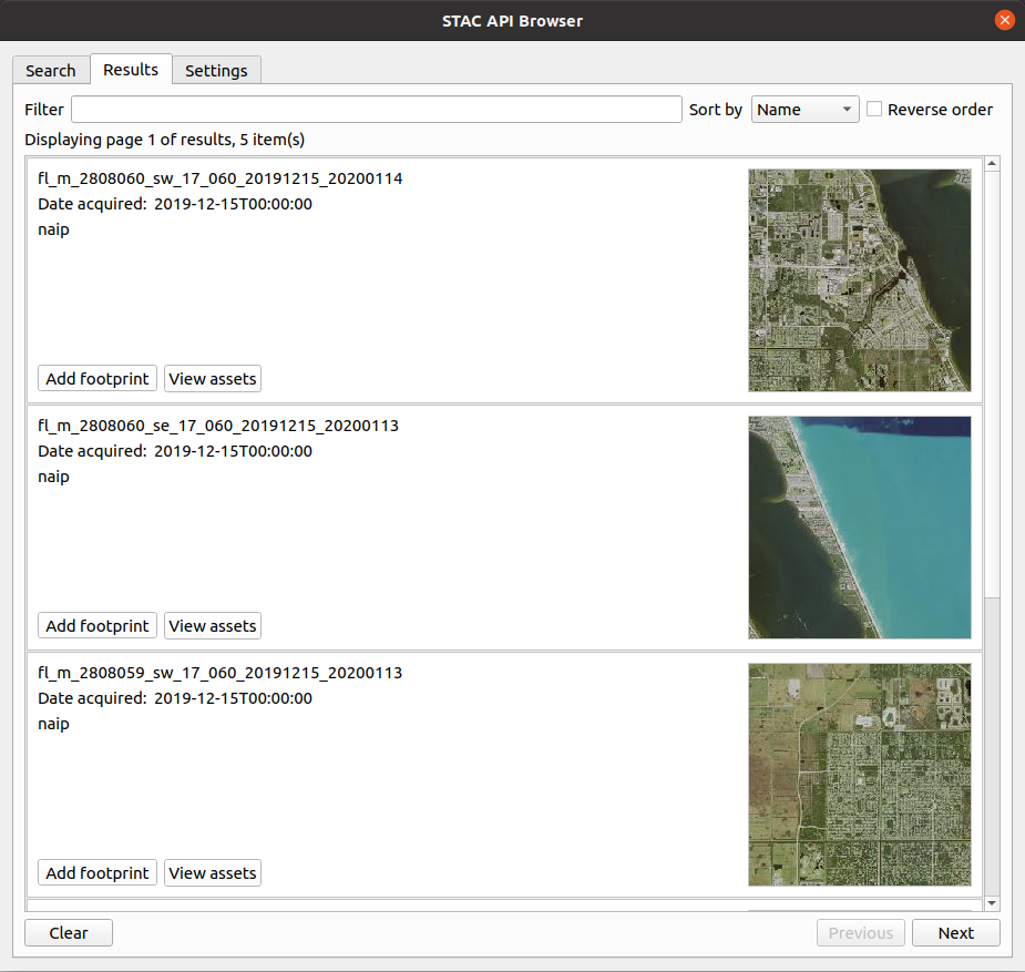
Example search result items
Item footprint and assets
The plugin enables loading STAC item assets and footprints in QGIS as map layers. After searching is complete, an item's footprint and assets can be viewed and added inside QGIS.
Adding and downloading item assets
The plugin currently supports loading assets as Cloud optimised GeoTIFF (CoG) layers in QGIS. To add the assets into QGIS canvas, click the View assets button from the required result item.
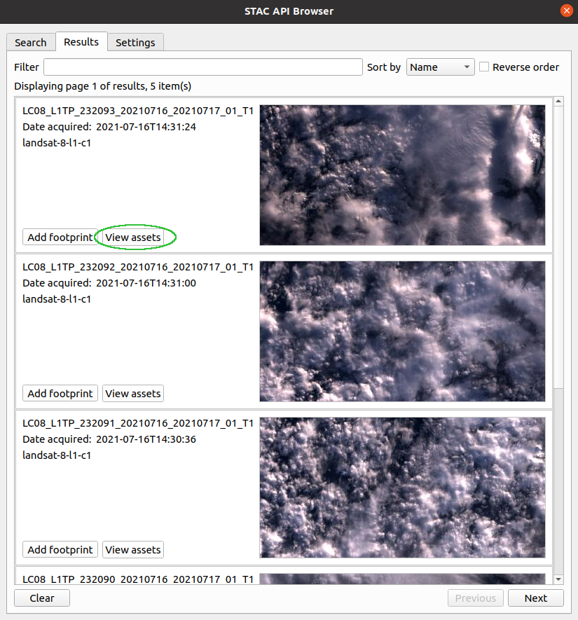
Image showing the button used for viewing the STAC item assets
The assets dialog will be opened. From the assets list click the Add assets as layers button to add the item into QGIS as a CoG layer. To download the asset click the Download asset button.
Notes
The STAC API plugin source code is published with a GPL v3 licence and the source code is availalbe in this Github repository.
If you have any issue or question when using the plugin or a support or new feature request please visit the issue page and see the documentation.
See Chris Holme's STAC Update, which refers to this post.
Share on Twitter Share on Facebook Kartoza
Comments
Comment awaiting approval 2 months, 3 weeks ago
Comment awaiting approval 2 months, 2 weeks ago
Comment awaiting approval 2 months, 2 weeks ago
Comment awaiting approval 2 months, 2 weeks ago
Comment awaiting approval 2 months, 2 weeks ago
Comment awaiting approval 2 months, 1 week ago
Comment awaiting approval 2 months, 1 week ago
Comment awaiting approval 2 months, 1 week ago
Comment awaiting approval 2 months ago
Comment awaiting approval 2 months ago
Comment awaiting approval 1 month, 4 weeks ago
Comment awaiting approval 1 month, 3 weeks ago
Comment awaiting approval 1 month, 3 weeks ago
Comment awaiting approval 1 month, 3 weeks ago
Comment awaiting approval 1 month, 3 weeks ago
Comment awaiting approval 1 month, 3 weeks ago
Comment awaiting approval 1 month, 3 weeks ago
Comment awaiting approval 1 month, 3 weeks ago
Comment awaiting approval 1 month, 3 weeks ago
Comment awaiting approval 1 month, 3 weeks ago
Comment awaiting approval 1 month, 3 weeks ago
Comment awaiting approval 1 month, 3 weeks ago
Comment awaiting approval 1 month, 3 weeks ago
Comment awaiting approval 1 month, 3 weeks ago
Comment awaiting approval 1 month, 3 weeks ago
Comment awaiting approval 1 month, 3 weeks ago
Comment awaiting approval 1 month, 3 weeks ago
Comment awaiting approval 1 month, 2 weeks ago
Comment awaiting approval 1 month, 2 weeks ago
Comment awaiting approval 1 month, 2 weeks ago
Comment awaiting approval 1 month, 2 weeks ago
Comment awaiting approval 1 month, 2 weeks ago
Comment awaiting approval 1 month, 2 weeks ago
Comment awaiting approval 1 month, 2 weeks ago
Comment awaiting approval 1 month, 2 weeks ago
Comment awaiting approval 1 month, 2 weeks ago
Comment awaiting approval 1 month, 2 weeks ago
Comment awaiting approval 1 month, 2 weeks ago
Comment awaiting approval 1 month, 2 weeks ago
Comment awaiting approval 1 month, 2 weeks ago
Comment awaiting approval 1 month, 2 weeks ago
Comment awaiting approval 1 month, 2 weeks ago
Comment awaiting approval 1 month, 2 weeks ago
Comment awaiting approval 1 month, 2 weeks ago
Comment awaiting approval 1 month, 2 weeks ago
Comment awaiting approval 1 month, 2 weeks ago
Comment awaiting approval 1 month, 2 weeks ago
Comment awaiting approval 1 month, 2 weeks ago
Comment awaiting approval 1 month, 2 weeks ago
Comment awaiting approval 1 month, 2 weeks ago
Comment awaiting approval 1 month, 2 weeks ago
Comment awaiting approval 1 month, 2 weeks ago
Comment awaiting approval 1 month, 2 weeks ago
Comment awaiting approval 1 month, 2 weeks ago
Comment awaiting approval 1 month, 2 weeks ago
Comment awaiting approval 1 month, 2 weeks ago
Comment awaiting approval 1 month, 2 weeks ago
Comment awaiting approval 1 month, 2 weeks ago
Comment awaiting approval 1 month, 2 weeks ago
Comment awaiting approval 1 month, 2 weeks ago
Comment awaiting approval 1 month, 2 weeks ago
Comment awaiting approval 1 month, 2 weeks ago
Comment awaiting approval 1 month, 2 weeks ago
Comment awaiting approval 1 month, 2 weeks ago
Comment awaiting approval 1 month, 2 weeks ago
Comment awaiting approval 1 month, 2 weeks ago
Comment awaiting approval 1 month, 2 weeks ago
Comment awaiting approval 1 month, 2 weeks ago
Comment awaiting approval 1 month, 2 weeks ago
Comment awaiting approval 1 month, 1 week ago
Comment awaiting approval 1 month, 1 week ago
Comment awaiting approval 1 month, 1 week ago
Comment awaiting approval 1 month, 1 week ago
Comment awaiting approval 1 month, 1 week ago
Comment awaiting approval 1 month, 1 week ago
Comment awaiting approval 1 month, 1 week ago
Comment awaiting approval 1 month, 1 week ago
Comment awaiting approval 1 month, 1 week ago
Comment awaiting approval 1 month, 1 week ago
Comment awaiting approval 1 month, 1 week ago
Comment awaiting approval 1 month, 1 week ago
Comment awaiting approval 1 month, 1 week ago
Comment awaiting approval 1 month, 1 week ago
Comment awaiting approval 1 month, 1 week ago
Comment awaiting approval 1 month, 1 week ago
Comment awaiting approval 1 month, 1 week ago
Comment awaiting approval 1 month, 1 week ago
Comment awaiting approval 1 month, 1 week ago
Comment awaiting approval 1 month, 1 week ago
Comment awaiting approval 1 month, 1 week ago
Comment awaiting approval 1 month, 1 week ago
Comment awaiting approval 1 month, 1 week ago
Comment awaiting approval 1 month, 1 week ago
Comment awaiting approval 1 month, 1 week ago
Comment awaiting approval 1 month, 1 week ago
Comment awaiting approval 1 month, 1 week ago
Comment awaiting approval 1 month, 1 week ago
Comment awaiting approval 1 month, 1 week ago
Comment awaiting approval 1 month, 1 week ago
Comment awaiting approval 1 month, 1 week ago
Comment awaiting approval 1 month, 1 week ago
Comment awaiting approval 1 month, 1 week ago
Comment awaiting approval 1 month, 1 week ago
Comment awaiting approval 1 month, 1 week ago
Comment awaiting approval 1 month, 1 week ago
Comment awaiting approval 1 month ago
Comment awaiting approval 1 month ago
Comment awaiting approval 1 month ago
Comment awaiting approval 1 month ago
Comment awaiting approval 1 month ago
Comment awaiting approval 1 month ago
Comment awaiting approval 1 month ago
Comment awaiting approval 1 month ago
Comment awaiting approval 1 month ago
Comment awaiting approval 1 month ago
Comment awaiting approval 1 month ago
Comment awaiting approval 1 month ago
Comment awaiting approval 1 month ago
Comment awaiting approval 1 month ago
Comment awaiting approval 1 month ago
Comment awaiting approval 1 month ago
Comment awaiting approval 1 month ago
Comment awaiting approval 1 month ago
Comment awaiting approval 1 month ago
Comment awaiting approval 1 month ago
Comment awaiting approval 1 month ago
Comment awaiting approval 1 month ago
Comment awaiting approval 1 month ago
Comment awaiting approval 1 month ago
Comment awaiting approval 1 month ago
Comment awaiting approval 1 month ago
Comment awaiting approval 1 month ago
Comment awaiting approval 1 month ago
Comment awaiting approval 1 month ago
Comment awaiting approval 1 month ago
Comment awaiting approval 1 month ago
Comment awaiting approval 4 weeks, 1 day ago
Comment awaiting approval 4 weeks, 1 day ago
Comment awaiting approval 4 weeks, 1 day ago
Comment awaiting approval 4 weeks, 1 day ago
Comment awaiting approval 4 weeks, 1 day ago
Comment awaiting approval 4 weeks, 1 day ago
Comment awaiting approval 4 weeks ago
Comment awaiting approval 3 weeks, 6 days ago
Comment awaiting approval 3 weeks, 6 days ago
Comment awaiting approval 3 weeks, 6 days ago
Comment awaiting approval 3 weeks, 5 days ago
Comment awaiting approval 3 weeks, 5 days ago
Comment awaiting approval 3 weeks, 4 days ago
Comment awaiting approval 3 weeks, 4 days ago
Comment awaiting approval 3 weeks, 4 days ago
Comment awaiting approval 3 weeks, 4 days ago
Comment awaiting approval 3 weeks, 4 days ago
Comment awaiting approval 3 weeks, 4 days ago
Comment awaiting approval 3 weeks, 4 days ago
Comment awaiting approval 3 weeks, 3 days ago
Comment awaiting approval 3 weeks, 3 days ago
Comment awaiting approval 3 weeks, 3 days ago
Comment awaiting approval 3 weeks, 3 days ago
Comment awaiting approval 3 weeks, 2 days ago
Comment awaiting approval 3 weeks, 2 days ago
Comment awaiting approval 3 weeks, 2 days ago
Comment awaiting approval 3 weeks, 2 days ago
Comment awaiting approval 3 weeks, 1 day ago
Comment awaiting approval 3 weeks, 1 day ago
Comment awaiting approval 3 weeks, 1 day ago
Comment awaiting approval 3 weeks, 1 day ago
Comment awaiting approval 3 weeks ago
Comment awaiting approval 3 weeks ago
Comment awaiting approval 3 weeks ago
Comment awaiting approval 3 weeks ago
Comment awaiting approval 3 weeks ago
Comment awaiting approval 3 weeks ago
Comment awaiting approval 2 weeks, 6 days ago
Comment awaiting approval 2 weeks, 6 days ago
Comment awaiting approval 2 weeks, 6 days ago
Comment awaiting approval 2 weeks, 6 days ago
Comment awaiting approval 2 weeks, 6 days ago
Comment awaiting approval 2 weeks, 5 days ago
Comment awaiting approval 2 weeks, 5 days ago
Comment awaiting approval 2 weeks, 5 days ago
Comment awaiting approval 2 weeks, 5 days ago
Comment awaiting approval 2 weeks, 5 days ago
Comment awaiting approval 2 weeks, 5 days ago
Comment awaiting approval 2 weeks, 5 days ago
Comment awaiting approval 2 weeks, 4 days ago
Comment awaiting approval 2 weeks, 4 days ago
Comment awaiting approval 2 weeks, 4 days ago
Comment awaiting approval 2 weeks, 4 days ago
Comment awaiting approval 2 weeks, 3 days ago
Comment awaiting approval 2 weeks, 3 days ago
Comment awaiting approval 2 weeks, 2 days ago
Comment awaiting approval 2 weeks, 1 day ago
Comment awaiting approval 2 weeks, 1 day ago
Comment awaiting approval 2 weeks, 1 day ago
Comment awaiting approval 2 weeks, 1 day ago
Comment awaiting approval 2 weeks, 1 day ago
Comment awaiting approval 2 weeks, 1 day ago
Comment awaiting approval 2 weeks ago
Comment awaiting approval 2 weeks ago
Comment awaiting approval 2 weeks ago
Comment awaiting approval 2 weeks ago
Comment awaiting approval 1 week, 6 days ago
Comment awaiting approval 1 week, 6 days ago
Comment awaiting approval 1 week, 5 days ago
Comment awaiting approval 1 week, 5 days ago
Comment awaiting approval 1 week, 5 days ago
Comment awaiting approval 1 week, 5 days ago
Comment awaiting approval 1 week, 5 days ago
Comment awaiting approval 1 week, 5 days ago
Comment awaiting approval 1 week, 5 days ago
Comment awaiting approval 1 week, 4 days ago
Comment awaiting approval 1 week, 4 days ago
Comment awaiting approval 1 week, 3 days ago
Comment awaiting approval 1 week, 3 days ago
Comment awaiting approval 1 week, 3 days ago
Comment awaiting approval 1 week, 3 days ago
Comment awaiting approval 1 week, 3 days ago
Comment awaiting approval 1 week, 3 days ago
Comment awaiting approval 1 week, 3 days ago
Comment awaiting approval 1 week, 1 day ago
Comment awaiting approval 1 week ago
Comment awaiting approval 1 week ago
Comment awaiting approval 1 week ago
Comment awaiting approval 1 week ago
Comment awaiting approval 1 week ago
Comment awaiting approval 1 week ago
Comment awaiting approval 1 week ago
Comment awaiting approval 6 days, 16 hours ago
Comment awaiting approval 5 days, 9 hours ago
Comment awaiting approval 5 days, 9 hours ago
Comment awaiting approval 5 days, 8 hours ago
Comment awaiting approval 4 days, 12 hours ago
Comment awaiting approval 4 days, 12 hours ago
Comment awaiting approval 4 days, 12 hours ago
Comment awaiting approval 4 days, 12 hours ago
Comment awaiting approval 4 days, 12 hours ago
Comment awaiting approval 4 days, 12 hours ago
Comment awaiting approval 4 days, 12 hours ago
Comment awaiting approval 4 days, 8 hours ago
Comment awaiting approval 4 days, 7 hours ago
Comment awaiting approval 4 days, 7 hours ago
Comment awaiting approval 4 days, 7 hours ago
Comment awaiting approval 4 days, 7 hours ago
Comment awaiting approval 4 days, 4 hours ago
Comment awaiting approval 3 days, 21 hours ago
Comment awaiting approval 3 days, 20 hours ago
Comment awaiting approval 3 days, 20 hours ago
Comment awaiting approval 3 days, 20 hours ago
Comment awaiting approval 3 days, 19 hours ago
Comment awaiting approval 3 days, 19 hours ago
Comment awaiting approval 3 days, 19 hours ago
Comment awaiting approval 3 days, 18 hours ago
Comment awaiting approval 3 days, 12 hours ago
Comment awaiting approval 3 days, 2 hours ago
Comment awaiting approval 3 days, 1 hour ago
Comment awaiting approval 3 days ago
Comment awaiting approval 3 days ago
Comment awaiting approval 3 days ago
Comment awaiting approval 3 days ago
Comment awaiting approval 2 days, 23 hours ago
Comment awaiting approval 2 days, 22 hours ago
Comment awaiting approval 2 days, 20 hours ago
Comment awaiting approval 2 days, 20 hours ago
Comment awaiting approval 2 days, 19 hours ago
Comment awaiting approval 2 days, 19 hours ago
Comment awaiting approval 2 days, 18 hours ago
Comment awaiting approval 2 days, 17 hours ago
Comment awaiting approval 2 days, 14 hours ago
Comment awaiting approval 2 days, 11 hours ago
Comment awaiting approval 2 days, 10 hours ago
Comment awaiting approval 2 days, 9 hours ago
Comment awaiting approval 2 days, 8 hours ago
Comment awaiting approval 2 days, 8 hours ago
Comment awaiting approval 2 days, 8 hours ago
Comment awaiting approval 2 days, 6 hours ago
Comment awaiting approval 1 day, 18 hours ago
Comment awaiting approval 1 day, 18 hours ago
Comment awaiting approval 1 day, 16 hours ago
Comment awaiting approval 1 day, 16 hours ago
Comment awaiting approval 1 day, 16 hours ago
Comment awaiting approval 1 day, 16 hours ago
Comment awaiting approval 1 day, 16 hours ago
Comment awaiting approval 1 day, 16 hours ago
Comment awaiting approval 1 day, 16 hours ago
Comment awaiting approval 1 day, 13 hours ago
Comment awaiting approval 1 day, 12 hours ago
Comment awaiting approval 1 day, 12 hours ago
Comment awaiting approval 1 day, 12 hours ago
Comment awaiting approval 1 day, 11 hours ago
Comment awaiting approval 1 day, 2 hours ago
Comment awaiting approval 1 day, 2 hours ago
Comment awaiting approval 1 day, 1 hour ago
Comment awaiting approval 23 hours, 27 minutes ago
Comment awaiting approval 22 hours, 34 minutes ago
Comment awaiting approval 22 hours, 33 minutes ago
Comment awaiting approval 22 hours, 32 minutes ago
Comment awaiting approval 22 hours, 21 minutes ago
Comment awaiting approval 19 hours, 17 minutes ago
Comment awaiting approval 18 hours ago
Comment awaiting approval 17 hours, 59 minutes ago
Comment awaiting approval 17 hours, 59 minutes ago
Comment awaiting approval 17 hours, 20 minutes ago
Comment awaiting approval 11 hours, 31 minutes ago
Comment awaiting approval 11 hours, 31 minutes ago
Comment awaiting approval 8 hours, 21 minutes ago
Comment awaiting approval 6 hours, 46 minutes ago
Comment awaiting approval 6 hours, 39 minutes ago
Comment awaiting approval 6 hours, 33 minutes ago
Comment awaiting approval 6 hours, 31 minutes ago
Comment awaiting approval 5 hours, 6 minutes ago
Comment awaiting approval 3 hours, 52 minutes ago
Comment awaiting approval 18 minutes ago
New Comment